The Ossipee Mullet, Part IV - The Proving Pole in the Front, Cover-Up in the Back
- Edwin Preble
- Apr 6
- 5 min read

This is about the one thing still standing there like it never got the memo:
a single telephone pole.
Not a whole utility corridor.
Not some dramatic transmission line humming like a sci-fi prop.
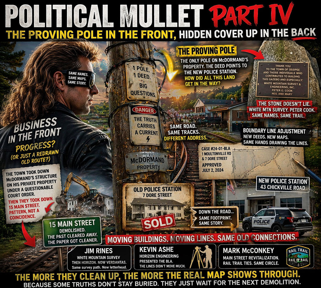
Just one lonely pole on McDormand’s property.
And here is the part that makes it interesting: it is not even the pole McDormand uses.
That pole appears to serve the Berry side.
Which would be odd enough on its own.
But it gets a whole lot more Ossipee when you follow the deed trail, because McDormand’s argument is that the pole connection points toward land that should tie through to what is now the new police-station side — even though today the map makes that whole stretch look chopped up, cleaned up, and politely disconnected.
So the question becomes:
If the paper says all these places are now nice, separate, modern little islands, why is one stubborn pole still acting like the old route never really changed?
That is not just a utility question.
That is a map question.
A title question.
A who-moved-what-on-paper question.
Because in Part III, the point was not merely that McDormand says his line is wrong. The point was that his parcel may be tied to the older controlling layout itself — the place where correcting one misrepresented lot could start showing how the surrounding lines should fall back into place.
Part IV picks up right there.
Because the one abutter sitting between McDormand’s land and the other land he says belongs with that chain is Berry — the same Berry tied to the 2019 BLA fight, the same adjustment where McDormand objected on the record, the same process that raised questions about monuments, waivers, and whether the line being approved matched the older deed reality.
So this is not a new story.
This is the old story growing sideburns.
Back in 2019, McDormand objected that the line shown did not match the deeds, that it was off to the west, and that the physical evidence on the ground did not line up with the survey story being presented. Yet the BLA moved ahead anyway.
And that matters even more now if Berry is not just an abutter on paper, but also the person functionally tied to the one pole sitting on McDormand’s lot while the rest of the corridor has been made to look separate.
Because once you frame it that way, the pole stops looking random.
It starts looking like a surviving breadcrumb from the older layout.
And then the story gets even more crowded.
Because this same corridor is also where the town demolished a structure on McDormand’s private property under what he argues was a misuse of a court order.
Then the town demolished 15 Main Street.
Different structure.
Different explanation.
Same broad effect: remove what is physically there, simplify the visible landscape, and make the paper version easier to sell afterward.
That is the part that should make people stop and put the coffee down.
Because every time one more building comes down, one more lot line gets adjusted, one more parcel gets “cleaned up,” and one more property is repackaged as a tidy standalone story, the town may think it is clearing the board.
But it may actually be exposing the older linework more.
That is the twist in the mullet.
The more they clean up the front, the more the back starts showing.
And nowhere is that more obvious than with the police-station move.
The town sold the move as progress. New location. Better fit. Fresh start. Everybody smile for the brochure.
But physically, the police department did not move to Mars.
It moved farther down the same road corridor and, by McDormand’s reading of the older land pattern, farther down the same old track line.
So the address changed.
The route did not.
And that matters because once you put the old PD, 15 Main Street, and the new PD in the same frame, they stop reading like unrelated town errands and start reading like connected stops along the same corridor.
Then there’s the Stone
At the Main Street location, the commemorative stone publicly thanks White Mountain Survey & Engineering, Inc. and Peter G. Cook.
Which is a pretty remarkable little granite cameo when the same names or deed trails keep turning up in the broader map and title questions.
Because McDormand’s position is not just that his lot is off. It is that the surrounding ownership story has been misrepresented, and that land now shown under Peter Cook’s name is part of that larger distortion. Tied to land not only near his property but also located on deeds tied to Preble park, where Mr Rines has recently moved.
So when the Main Street site itself also carries a public White Mountain Survey / Peter Cook marker, it starts feeling less like decorative civic gratitude and more like the world’s most passive-aggressive exhibit sticker.
And White Mountain Survey, of course, ties into the Rines side of the story.
So now you have:
McDormand’s disputed parcel.
Berry as the abutter in the middle.
The pole serving the wrong side.
A 2019 BLA pushed through over objection.
Waivers in the process.
A selectman-relative connection at the time of the adjustment, as McDormand alleges.
The old PD parcel and new PD parcel raising questions about whether the deeds read more like access rights than clean fee ownership.
15 Main Street demolished.
McDormand’s structure demolished.
And the same survey/deed names continuing to pop up along the corridor like they all carpooled.
At some point, coincidence starts looking less like coincidence and more like it needs minutes, a chairman, and a second motion.
And that is what makes the Berry piece so important.
Because Berry is not just some random nearby name in the deed book.
In this story, Berry is the hinge.
The person between McDormand’s parcel and the other land McDormand says belongs with it.
The abutter tied to the one usable function of the one pole on McDormand’s lot.
The same name tied to the contested 2019 adjustment.
The person tied to the towns prior administrator, and selectman
So when people ask why McDormand keeps bringing this up, the better question is:
Why does the same narrow stretch of land keep producing the same names, the same survey fingerprints, the same cleanup moves, and the same feeling that the modern parcel story is a little too neat for what the older deeds seem to be saying?
Because if the old and new police-station deeds really trace more to timber access than true fee ownership, that is not some footnote.
That is a giant neon asterisk.
It means the town may have been shifting buildings, boundaries, and public explanations around parcels whose underlying ownership story is not nearly as solid and simple as the modern map wants people to believe.
And if that is true, then the move down the road is doing more than relocating the police department.
It is accidentally lighting up the corridor.
That is the punchline here.
The town may think it moved the PD.
But what it may actually have done is move the spotlight.
Because now the old PD, the new PD, 15 Main Street, the Berry adjustment, the White Mountain / Peter Cook stone, and McDormand’s one proving pole all keep circling back to the same question:
What if this whole stretch was never as separate as the current paper wants it to look?
That is the Ossipee political mullet in full bloom.
Business in the front: new station, new parcels, new paperwork, new branding, fresh explanations.
Party in the back: old deeds, old access rights, old corridor, old survey names, one abutter in the middle, and one rude little pole still pointing the wrong way.
And honestly, that may be the most revealing thing in town.
Not the building.
Not the budget.
Not the ribbon-cutting.
The pole.
Because sometimes the smallest thing on the lot is the one thing that refuses to lie.


Comments